Education
Restoration
Preservation
Welcome to the
Healy Project
Join us on Facebook
Send us an Email
Who Lives in Lowry Hill East?
Note: The article below appears in the April 2013 edition of The Wedge, neighborhood newspaper of Lowry Hill East. I wrote it as a report. After the article I’ve added some editorial comments.
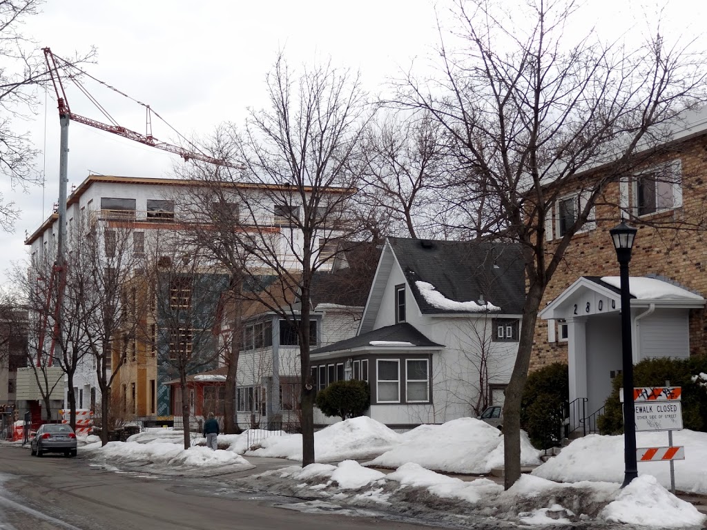 |
| The west side of the 2800 block of Colfax Ave. S in the Greenway: a 1970’s 2-1/2-story walkup, three modest-sized houses, and two apartment buildings under construction. |
The Three Wedges
Bisected by high-traffic streets, Lowry Hill East is divided into three sections by zoning designations: the area south of 28th Street, the large section between 24th and 28th Streets, and the apex north of 24th. Each of these sections has a distinctive character and its own set of concerns. While there is no way to distinguish between the demographics of each section, looking at the Wedge as a whole in comparison to the greater city sheds some light on a major issue facing the neighborhood currently and in the future: redevelopment of the Wedge apex north of 24th Street.
The most recent source of demographical data is the 2010 census, which shows the population of the Wedge to differ significantly from that of the city of Minneapolis.* The Wedge has a higher percentage of white residents (84% versus 60%), residents 18-44 years of age (78-50), structures with two or more units (91-50), renter-occupied units (83- 51), residents with a bachelor’s degree or higher (62-43), and persons living alone (59-40). On the other hand, the Wedge has fewer households with children (15-44), owner-occupants (17-49), householders over 65 years of age (3-8), and residents under 18 (5.5-20).
While the median income of Wedge residents is about 4% less than the city’s ($43,922 versus $45,625), the income of the majority is centered around the median, with fewer on the high end. Only 17.5% of Wedge residents make more than $3,333 per month, as compared with 54% citywide; on the other hand, 43% of Wedge residents earn less than $1,250 monthly, as opposed to 18% citywide.
From 1990 to 2010, the population remained fairly stable, 5,933 versus 6,150. But the Wedge has a huge turnover in residents from one year to the other, 40% versus 24% citywide. More than half of Wedge residents (54.5%) moved into the neighborhood in 2005 or later, compared with 37% citywide. Only 2.7% (versus 9% citywide) called the Wedge home prior to 1979. Not surprisingly, renters outnumber homeowners about 5:1.
Those are the demographics of the Wedge as a whole as of 2010. While we don’t know demographical differences in the three Wedge sections, we can look at what distinguishes them physically. The southernmost section is currently undergoing significant changes. Formerly an industrial corridor along railroad tracks, the area south of 28th Street is being transformed into a high-density residential area of apartments, condos, and townhouses. The total number of new units under construction (839) and already built (1,061) south of 28th Street is 1,890. Assuming that each unit will house 1.5 residents (the current Wedge average), these nearly 2,800 new residents will swell the current population of the Wedge by 47%, and constitute about one third of the total population.
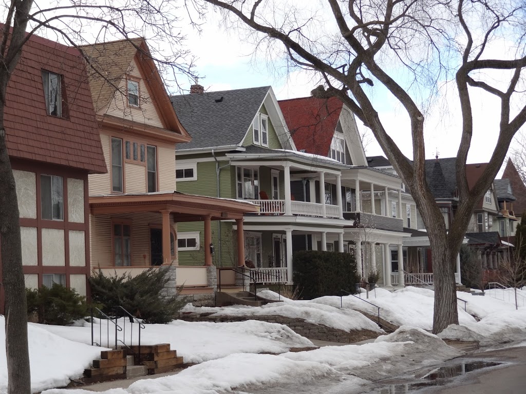 |
| The west side of the 2600 block of Colfax Avenue S: two large 1960’s apartment buildings and turn-of-the-century houses |
The interior of the big section between 24th and 28th Streets is largely comprised of pre-World War I houses and apartment buildings, with two-and-a-half-story walkup apartment buildings scattered among them. After its 1970’s downzoning to lower density, the Wedge middle has remained the most stable area, with the vast majority of residential buildings being occupied as they were thirty years ago. This section is home to most of the residents who have lived in the Wedge the longest. It has the most duplexes and single-family houses. This section, however, is cut in two by a major traffic artery (26th Street), and of the 28 blocks here only 12 whole blocks are zoned R2B.
The northernmost section, the apex north of 24th Street, is the smallest. In the first half of the 20th century, large houses, a school, and a church occupied this area. Some of the houses were used as student housing for this school and for the Dunwoody Institute. After the middle section was downzoned, high-density zoning remained in place for the Wedge apex. This writer’s count of the structures located in the area between 24th and Franklin revealed the following distribution: 5 pre-WWII apartment buildings; 19 post-WWII apartment buildings; 14 houses with 4 or more residential units; 60 houses with 3 or fewer units. Today a half-dozen single-family homes north of 24th Street are in R2B zoning, but the remainder is zoned for commercial or high density residential.
 |
| The west side of the 2300 block of Colfax Avenue S: the back of the funeral home parking lot and four 1890’s houses, three of them built by T.P.Healy, all currently rooming houses. |
Because of this high-density zoning, the apex is slated to be the next area facing big changes. Mayor Rybak and the City Planning Department have targeted the Wedge, Whittier, and other neighborhoods to the east for more high-density residential development. When the available space along Greenway is filled, developers’ attention will turn to the Wedge apex. A hint of what’s to come is the current proposal by the Lander Group to demolish the houses at 2316 and 2320 Colfax and replace them with a four-story apartment building. It’s only a matter of time that other redevelopment proposals will be offered to replace houses in the R6 part of the apex. If a proposed building conforms to R6 zoning, which allows for buildings as high as five stories, it can go in without neighborhood approval.
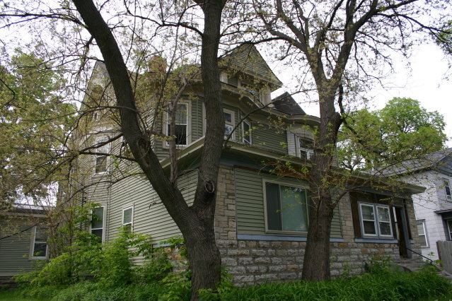 |
| Doomed by redevelopment? The Edward Orth House, 2320 Colfax, one of two houses developer Michael Lander intends to demolish for a four-story apartment building. |
The Wedge population has already seen a shift away from the number of families with children and a shift toward a greater proportion of young renters. In the coming months and years, Wedge residents will have to decide if they prefer new apartment buildings that offer many more units or if they’d rather have the 74 turn-of-the- century houses (two fewer if the Lander project is built) lining the streets of the apex.
In 2011 Council Member Meg Tuthill requested that Community Planning and Economic Development (CPED) staff put on their work plan a review of LHENA’s 2004 Zoning Study. This was proposed to preserve the mixed scale and diverse character of the neighborhood.
With the high proportion of Wedge residents being renters and a high year-to-year turnover, it’s apparent that only a small percentage of residents are involved in LHENA and neighborhood events. If you’re reading this article, you probably care about what happens in the Wedge. If so, speak your mind—or someone else will decide what changes do and don’t come to pass in Lowry Hill East.
________________________________________________________________________
*See: www.mncompass.org (October 2011)
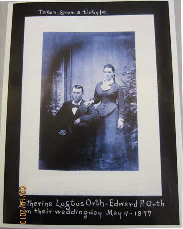 |
| A wedding portrait of Edward and Catherine Orth, 1877 |
++++++++++++++++++++++++++++++++++++++++++++++++++++++++
Commentary:
The country is emerging from a serious economic crisis that grew out of an unregulated boom-and-crash in mortgage banking. At the moment, most people under 30 cannot afford to buy houses. Thousands of them have moved out of their parents’ suburban homes to take up residence in the city. (Some are forecasting a coming crash in the suburban housing market as Baby Boomers downsize–but that’s another issue). How many of these young people would prefer living in their own houses over living in high-rise apartments? I suspect that when the time comes, many of these people will decide to move into houses or duplexes to raise their children rather than staying in apartments.
The new developments in the Greenway with their thousands of anticipated new residents are a faix accompli. One aspect that the City and the developers of these so-called multifamily apartment buildings never bring up–or seem even to consider–is the distinct possibility that they are overestimating the number of people who will want to and who can afford to live in these new units. After all, the Wedge is only one of several districts in the city where thousands of residential units are going up. The banks, developers, and City are plowing ahead on the assumption that all will go as they planned. What could possibly go wrong? (Famous last words.)
Some of what I found in researching this article surprised me–for one, the huge turnover in Wedge residents every year; for two, the high percentage of college-educated residents; and for three, the large percentage of residents who will live in the new Greenway buildings when all are completed.
I am part of a very small percentage of Wedge residents who moved in pre-1976. In another twenty-five years, most of us will not be living in the neighborhood (if we’re living at all). The neighborhood will inevitably undergo change. It will be up to the younger folks to decide what kind of a place they want to live in. Do they share the vision of the City for the Wedge: a small core of apartment buildings and old houses sandwiched in between two areas of new high-density residential developments, and encircled by commercial buildings and apartment complexes? Or do they think, as the neighborhood association has to date, that the scale and mix of old houses and apartments buildings, two-and-a-half story walkups and commercial that make up the Wedge should be preserved.
The battleground that is emerging is the Wedge apex north of 24th Street, an area zoned and ready for high-density development. Do we want two overbuilt “Greenways” (a misnomer if there ever was one) surrounding the surviving old houses in the neighborhood, or do we want to retain, through the changes that come with time, the distinctive character of our wonderful, diverse, funky old/new Wedge?
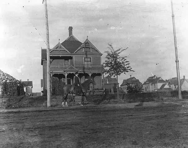 |
| The Wedge (when it wasn’t the Wedge) under development as a streetcar suburb in the 1890s, as seen from Lyndale Avenue. |